Sorting by "Updated at"
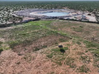
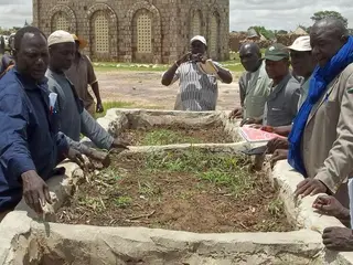
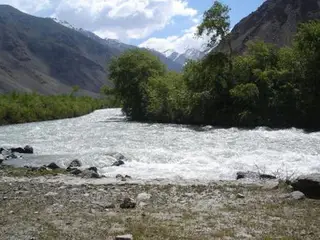
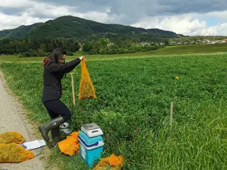
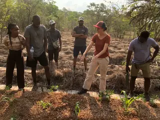
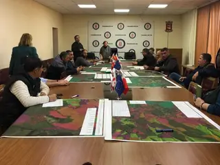
Kaluun-Dacar Water Harvesting Haffir [Сомали]
A water harvesting haffir constructed by the Barwaaqo Project in Kaluun-Dacar village, Galmudug State, designed to capture and store seasonal surface runoff from the Gu and Deyr rains for livestock, household use, and small-scale fodder production, while reducing soil erosion and enhancing drought resilience.
- Эмхэтгэгч:
- Abdulkadir Ali Mohamed
- First published:
- 2026-06-21 15:07
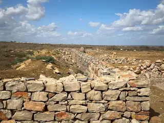
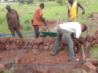
Integrated Land Management for Gully Erosion Control through Gabions and Rock Check Dams in Guri Gaab Village [Сомали]
This technology rehabilitates active gullies in degraded agro-pastoral land in Guri Gaab Village, Baidoa District, through the construction of six gabion structures and six rock check dams within a 160-hectare watershed. The intervention was implemented to address severe gully erosion, loss of productive land, rapid runoff, and declining vegetation cover.
- Эмхэтгэгч:
- ABDULLAHI ABDULKADIR
- First published:
- 2026-06-20 09:12
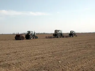
Pasture rotation in the desert areas of Uzbekistan (CACILM) [Узбекистан]
Improvement of a livestock grazing scheme ensuring the restoration of pasture vegetation and observance of appropriate pasture loading.
- Эмхэтгэгч:
- Rustam Ibragimov
- First published:
- 2017-01-04 10:52
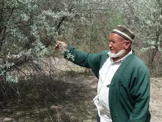
Saxaul plantation for stabilisation of sandy soils [Тажикистан]
Saxaul (Haloxylon ammodendron) bushes are planted on denuded sandy soils with the aim to reduce the rate of desertification.
- Эмхэтгэгч:
- Firdavs Faizulloev
- First published:
- 2017-03-15 16:01
Valley floor paddey cultivation through traditional system [Бангладеш]
The traditional approach of valley floor terraced rice cultivation at individual household level for their subsistance.
- Эмхэтгэгч:
- Niaz Ahmed Khan
- First published:
- 2017-08-03 08:44
Using organic fertilizers on small-scale irrigation plots [Мали]
Organic fertiliser enhances the productivity of the soil, as well as its capacity for infiltration and water retention.
- Эмхэтгэгч:
- Dieter Nill
- First published:
- 2017-07-10 12:05
Rehabilitation of poor soils through agroforestry [Тажикистан]
An agroforestry system with peach, plum, sweet cherry and persimmon trees was established on a plot of land, with poor soil quality.
- Эмхэтгэгч:
- Natalia Mityakova
- First published:
- 2017-03-15 15:12
Pest management with pheromone insect traps [Тажикистан]
Coloured pheromone traps are set up in agricultural fields to attract and eradicate flying insect pests.
- Эмхэтгэгч:
- Firdavs Faizulloev
- First published:
- 2017-03-15 11:26
Rehabilitation of iron water gates to improve distribution of irrigation water [Тажикистан]
The recycling of broken iron water gates which can be used to regulate the water flow into smaller side canals were reconstructed along the main irrigation canal.
- Эмхэтгэгч:
- Natalia Mityakova
- First published:
- 2017-03-15 14:08
Tugai forest management through village committees [Тажикистан]
The described approach facilitates the establishment of contracts between village committees and local authorities for decentralised management of Tugai forest areas on State Reserve Land.
- Эмхэтгэгч:
- Firdavs Faizulloev
- First published:
- 2017-07-06 14:38
Fallow restoration by no-tillage seeding [Казахстан]
Fallow land restoration for fodder production is combined with biodiversity conservation of natural steppe vegetation by no-tillage disc-harrowing and seeding of forage grass in low density.
- Эмхэтгэгч:
- Heino Hertel
- First published:
- 2017-05-28 17:21
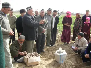
Central Asian Countries Initiative for Sustainable Land Management (CACILM) [Тажикистан]
Farmer Field Schools (FFS) are held to fill farmer's gaps in knowledge on the use of sustainable agricultural technologies, efficient irrigation water use and prevention of land degradation using trials tailored to local conditions.
- Эмхэтгэгч:
- Firdavs Faizulloev
- First published:
- 2017-07-06 10:51
Establishment of educational ranger stations to involve youth in nature protection activity [Казахстан]
Establishment and activity of educational ranger stations on the basis of forestry units and secondary schools to involve youth in nature protection activity to conserve, restore and study unique natural features of the Kazakh Altai (in the frame of CACILM).
- Эмхэтгэгч:
- Azhar Yeszhanova
- First published:
- 2017-08-03 16:28
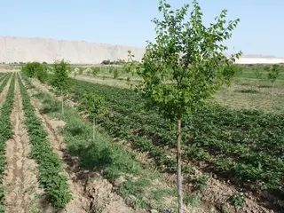
Planting poplar forest in the flood plains of high mountain river areas [Тажикистан]
The afforestation of the low productivity sandy lands in the river valley areas of arid highlands with fast growing poplar trees, provides the population with firewood as well as timber and also provides conservation benefits.
- Эмхэтгэгч:
- Gulniso Nekushoeva
- First published:
- 2017-03-15 17:23
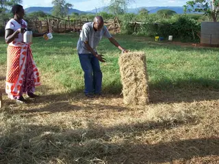
Soil and water conservation through pasture regeneration and hay production [Кени]
In this new technology the Maasai people set aside some acres of land, fence it and plant grass where the land is bear or allow natural standing grass to germinate then harvest it and store as hay for future use. This also helps in preventing soil erosion and surface run off.
- Эмхэтгэгч:
- SAIKO JOYCE
- First published:
- 2018-05-22 06:32
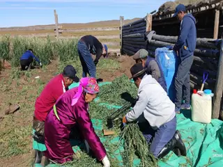
Household silage making in winter shelters [Монгол Улс]
Silage is a type of preserved, fermented fodder that is fed to livestock when grass is scarce or unavailable. Household-level silage production involves growing oats within winter/spring livestock shelters, chopping the harvested crop, and then compacting it in plastic tanks where it forms silage through an anaerobic process.
- Эмхэтгэгч:
- Mandakh Nyamtseren
- First published:
- 2026-05-11 08:36
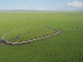
Buryat sheepfold-style fencing exclosures [Монгол Улс]
Buryat sheepfold fencing is a traditional Mongolian design. It has been adapted to form exclosures to protect springheads and wetland edges from trampling and overgrazing. This modified version was installed around four spring sources feeding the Ulz River to reduce soil compaction, erosion, and water contamination at the most sensitive points.
- Эмхэтгэгч:
- Tserendulam Tseren-Ochir
- First published:
- 2026-06-11 14:45
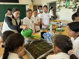
From Seed to Grove: Student-Led Bird Cherry Nursery [Монгол Улс]
Through “learning by doing” students have propagated bird cherry seedlings, established a grove within the school grounds, and distributed seedlings to local households. This ecological education initiative has been put into practice though the “Thank you, Moilhon” programme initiated by a “Green Island” school Eco-Club.
- Эмхэтгэгч:
- Tserendulam Tseren-Ochir
- First published:
- 2026-06-08 10:59
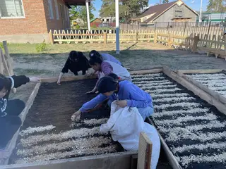
Producing wild cherry seedlings in a schoolyard nursery [Монгол Улс]
Wild cherry seeds are collected and sown in an open-air nursery within a schoolyard. The planting area is fenced by wooden boards and filled with a humus-rich soil and a light mulch, such as sawdust, is added to retain moisture and control weeds. This practice enhances the survival rate of seedlings – which are planted out in school groves as well as being available for regreening projects.
- Эмхэтгэгч:
- Mandakh Nyamtseren
- First published:
- 2026-05-29 13:14
Restoring degraded land through grass planting for livestock production [Лаос]
Degraded maize fields are converted into grassland to improve livestock management and restore soil health. After five years of maize cultivation, yields declined as the once fertile soil became sandy and dry. Grass planting offered a sustainable alternative, improving ground cover, moisture, and feed availability.
- Эмхэтгэгч:
- TOUBEE VODETPHAYBOUNE
- First published:
- 2026-05-25 14:00
Integrating Garlic into Rice Crop Rotation [Лаос]
Crop rotation in rice fields maximizes paddy land use during the dry season, particularly through the cultivation of garlic, onion, and other vegetables.
- Эмхэтгэгч:
- Viengkeo Bounthavongkham
- First published:
- 2026-05-25 12:23
Crimson clover as an overwintering cover crop for nitrogen supply [Словени]
Crimson clover, overwintered as a cover crop, forms a symbiotic relationship with nitrogen-fixing bacteria, capturing nitrogen and thus enriching the soil. This helps reduce the need for synthetic fertilizers and aids in soil erosion control, weed suppression, and improved soil structure.
- Эмхэтгэгч:
- Tamara Korošec
- First published:
- 2025-10-27 09:34
Combating erosion, recovery and enhancement of degraded land and climate change adaptation (EKF Project) [Буркина фасо]
The approach applied in this project is an integrated and multi-stakeholder approach in the South West of Burkina Faso, based on watershed management and sustainable land management with a strong emphasis on local participation. It carries out physical and biological measures against erosion, adaptation to climate change and various activities of capacity building.
- Эмхэтгэгч:
- Rebecka Ridder
- First published:
- 2016-12-15 14:27
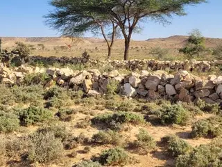
Cordons pierreux isohypses/diguettes/demi lunes /labour/ terres / [Буркина фасо]
Structure physique sous forme de cordons pierreux isohypses accompagnée par la réalisation de diguettes en demi lune et de petites trous de forme circulaire
- Эмхэтгэгч:
- Unknown User
- First published:
- 2017-07-10 16:15
Defensivo de piedra tipo "acantilado" [Боливи]
Defensivos flexibles y rústicos, se emplean para proteger terrenos de cultivo frente a amenazas de riadas y erosión lateral. Esta conformada de rocas de gran diámetro con altura y espesor variable que puede ser complementada con plantación de árboles. Su resistencia y flexibilidad permite que no se deforme fácilmente ante fuertes eventos de crecidas de agua.
- Эмхэтгэгч:
- Marco Loma
- First published:
- 2017-11-01 10:28
Ferias comunitarias campesinas como alternativa de comercialización para la mejora en la rentabilidad y mantenimiento de la actividad productiva tradicional. [Аргентин]
Ferias comunitarias campesinas como alternativa de comercialización para la mejora en la rentabilidad y mantenimiento de la actividad productiva tradicional.
- Эмхэтгэгч:
- Andrea Carrera
- First published:
- 2017-03-21 18:21
Miombo Restoration and FIAT Metric Validation in Chimanimani National Park [Мозамбик]
This approach combines ecological restoration of degraded Miombo woodlands and montane forests with the application of scientifically validated forest integrity assessment tools in Chimanimani National Park. It integrates participatory planning, establishment of permanent monitoring plots, assisted natural regeneration, and enrichment planting with native species, while using Miombo ecosystem metrics and the Forest Integrity Assessment Tool (FIAT) to monitor forest recovery and guide conservation management.
- Эмхэтгэгч:
- Silveira Manuessa
- First published:
- 2026-05-07 16:45
Intercropping of orange orchard with vegetables in southern Spain [Испани]
Intercropping in an orange trees orchard with no fertilization: Xixona, Alicante (Spain)
- Эмхэтгэгч:
- Alicia Morugán-Coronado
- First published:
- 2022-10-03 11:59

Soil and water conservation and pasture management through check dams and fencing [Сомали]
A soil and water conservation and pasture management technology implemented through area closure, fencing, and installation of check dams to control erosion and rehabilitate degraded rangelands.
- Эмхэтгэгч:
- salad ali
- First published:
- 2026-04-26 11:02
Reforestation of hills with participation of the community [Гаити]
In the Mornes region of Léogâne, the Swiss Red Cross (SRC) practices reforestation through community participation.
- Эмхэтгэгч:
- Joana Eichenberger
- First published:
- 2019-02-16 20:37

Soil and Water Conservation through Half-Moon Structures [Сомали]
The micro half-moon catchment (Bila Bilo) of Beyra is a soil and water conservation technology that harvests runoff, reduces erosion, and improves water infiltration in dryland areas. By capturing sediments and retaining soil moisture, it creates fertile micro-sites that support vegetation regeneration, land restoration, and climate change adaptation.
- Эмхэтгэгч:
- Faruq Dahir
- First published:
- 2026-04-26 11:02
Conversion of conventional monoculture farmland into a food forest [Израиль]
Converting conventional monoculture farmland into a food forest-based agroforestry system restores soil health, increases vegetation cover, enhances biodiversity while diversifying production. The intervention improves soil organic matter and ecological resilience through multi-storey planting, reduced soil disturbance, and nature-based land management.
- Эмхэтгэгч:
- Tom Cohen
- First published:
- 2025-11-12 07:46
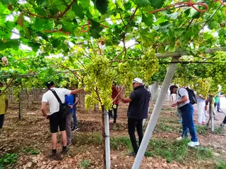
Organic Farming of Table Grapes [Итали]
Organic Farming (OF) of table grape production in Apulia region is estimated at 8.5% of the total area. The advantages of OF include an increase in soil organic matter, better water holding capacity and lower soil salinity.
- Эмхэтгэгч:
- Pandi Zdruli
- First published:
- 2025-10-16 13:56
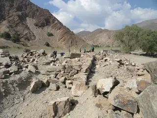
Rock Check Dam for Gully Erosion Control [Сомали]
Rock check dam is a small, low barrier built across gullies, or seasonal waterways to Reduce erosion, Increase water infiltration into the soil, etc Check dams are often used to restore degraded land, improve pasture, and support year-round grazing by helping water soak into the ground rather than washing soil away.
- Эмхэтгэгч:
- Nasteho Omar
- First published:
- 2026-04-26 11:02
Controlled Grazing [Жоржиа]
“Controlled Grazing” seeks to harness the behaviours and habits of ruminant livestock to enhance three key ecological functions, namely the removal of plant biomass (grazing), soil and vegetation disturbance (animal impact) and increased nutrient cycling (dung and urine), with the goal of increasing perennial grass establishment, pasture palatability and reducing bare ground and erosion.
- Эмхэтгэгч:
- Nicholas Euan Sharpe
- First published:
- 2026-01-09 12:45
Participatory Grassland and Rangeland Assessment (PRAGA) [Жоржиа]
The Participatory Rangelands and Grasslands Assessment Methodology (PRAGA) is a rapid, cost-effective framework for the integrated assessment of rangeland ecosystems, incorporating diverse data sources and participatory approaches. PRAGA facilitates stakeholder engagement through consultations and workshops, underpinned by community-based mapping of grazing areas, land use dynamics, and trend analyses.
- Эмхэтгэгч:
- Nicholas Euan Sharpe
- First published:
- 2025-12-16 08:26
Municipal Pastureland Planning [Жоржиа]
The Municipal Pastureland Planning approach was developed collaboratively with key national and local stakeholders to establish a structured, evidence-based decision support framework for sustainable rangeland governance. This system consolidates and presents data from diverse stakeholder groups in a format fully compatible with the Land Degradation Neutrality Framework, ensuring that planning aligns with both environmental and socio-economic objectives.
- Эмхэтгэгч:
- Nicholas Euan Sharpe
- First published:
- 2025-12-16 08:26
Potatoes Growing in Lowlands for Food Security Durnig Dry Seasons [Уганда]
Lowlands have relatively high water tables and contain sufficient soil moisture to permit potatoes growing. Potatoes can grow in such areas compared to other staple crops like cassava.
- Эмхэтгэгч:
- Bernard Fungo
- First published:
- 2020-05-14 17:04
Participatory Net Planning for Sustainable Watershed Management [Энэтхэг]
Participatory Net Planning (PNP) is a practical methodology that actively engages landowners and local stakeholders in planning and implementing measures for land use, soil conservation, water harvesting, and biomass development. It aims to regenerate ecosystems and improve the sustainability of watersheds through site-specific resource management. PNP emphasizes the conservation, productivity enhancement, and sustainable use of natural and biological resources. It involves assessing the current condition and use of land, water, and vegetation, and preparing detailed plans—with estimated costs and timelines—to achieve the desired outcomes. In Participatory Net Planning (PNP), the term “Net” represents a complete and interconnected planning framework where every land parcel within a watershed is individually assessed and linked to the larger watershed system. It highlights a network-based approach that integrates soil, water, vegetation, and community needs, ensuring that interventions on one farm support resource conservation and productivity across neighboring and downstream lands. Overall, it signifies a holistic and coordinated system where all stakeholders and resources are planned collectively for sustainable and long-term watershed management.
- Эмхэтгэгч:
- Arun Bhagat
- First published:
- 2025-12-06 16:34
Ecosystem based Adaptation (EbA) through Farmers’ Collectives for Sustainable Management of Natural Resources [Энэтхэг]
The Ecosystem-based Adaptation (EbA) with Farmer Collective (henceforth Farmer Producer Organisations (FPOs)) approach strengthens farmers’ resilience to climate change by integrating sustainable water- and land management, biodiversity enhancement and resources governance within farmers’ collectives. Implemented in semi-arid regions of Maharashtra and Telangana, the approach combines capacity building, improving soil health, through women-led green business aiming at enabling eco-sensitive and economically viable FPOs.
- Эмхэтгэгч:
- Arun Bhagat
- First published:
- 2025-11-30 12:40
- . . .